GEOLocate Registry entries
Series of Registry entries for configuring the embedded GEOLocate client in the Sites module.The following GEOLocate Registry entries are available:
Registry entry | Purpose | ||||||||||||||||||||||||||||||||||||||||||||||||||
|---|---|---|---|---|---|---|---|---|---|---|---|---|---|---|---|---|---|---|---|---|---|---|---|---|---|---|---|---|---|---|---|---|---|---|---|---|---|---|---|---|---|---|---|---|---|---|---|---|---|---|---|
GEOLocate|URL | Specifies the URL of the mapping service used by the embedded GEOLocate client in EMu. The GEOLocate Project "develops software and services for translating textual locality descriptions associated with biodiversity collections data into geographic coordinates"1. The embedded GEOLocate client in EMu's Sites module is configured to use the GEOLocate Project's services by pointing to the following URL (accurate at the time of writing): http://geo-locate.org/web/WebGeoreflight.aspx The URL is hard-coded into the EMu GEOLocate client. If the GEOLocate Project changes the URL, the embedded GEOLocate client will lose its connection to the GEOLocate service. This entry is available in the event that the URL changes and the connection is lost. Details about the new URL will be provided by Axiell Support. Specifying this Registry entry will restore the connection. This Registry entry is assigned at the system level only:
where:
| ||||||||||||||||||||||||||||||||||||||||||||||||||
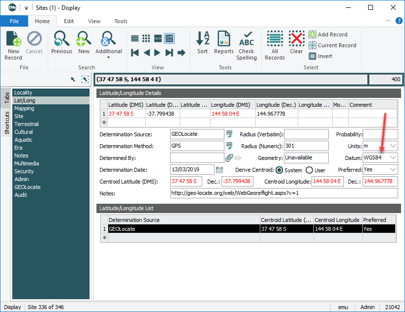
GEOLocate|Datum | Specifies the current revision of the World Geodetic System (WGS) standard. The World Geodetic System (WGS) is a standard for use in cartography, geodesy, and satellite navigation, including GPS. It comprises a standard coordinate system for the Earth, a standard spheroidal reference surface (the datum or reference ellipsoid) for raw altitude data, and a gravitational equipotential surface (the geoid) that defines the nominal sea level. The latest revision is WGS 84 (also known as WGS 1984, EPSG:4326), established in 1984 and last revised in 20042. This entry is used to specify the latest revision of the standard; the Datum field on the Lat/Long tab of the Sites module is auto-filled with this value: Note: This entry only applies when adding GEOLocate sourced geographic coordinates to EMu, e.g. when placing a marker / dropping a pin on the map on the GEOLocate tab and selecting Save To Your Application. As we see in the screenshot above, Determination Source = This Registry entry can be assigned to users, groups and system-wide:
where:
| ||||||||||||||||||||||||||||||||||||||||||||||||||
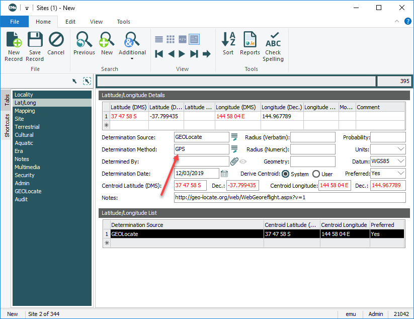
GEOLocate|Determination Method | Specify the default Determination method (auto-filling the Determination Method field on the Lat/Long tab of the Sites module). Geolocation is the process used to collect latitude and longitude (lat/long) coordinates that represent a specific location. Various methods can be used to determine geolocation coordinates, including GPS. This Registry entry specifies which method is used by default when adding geolocation data, auto-filling the Determination Method field on the Lat/Long tab of the Sites module when GEOLocate sourced geographic coordinates are added to EMu: Note: This entry only applies when adding GEOLocate sourced geographic coordinates to EMu, e.g. when placing a marker / dropping a pin on the map on the GEOLocate tab and selecting Save To Your Application. As we see in the screenshot above, Determination Source = This Registry entry can be assigned to users, groups and system-wide:
where:
This entry specifies that the determination method used when calculating geolocation coordinates for all users is GPS:
| ||||||||||||||||||||||||||||||||||||||||||||||||||
GEOLocate|Locality String Columns | Specifies one or more fields used to populate the Locality String field on the GEOLocate tab of the Sites module. This entry specifies one or more fields used to populate the Locality String field on the GEOLocate tab of the Sites module. If values from more than one field are to be combined, the GEOLocate|Locality String Delimiter Registry entry defines the delimiter (a comma for instance) used to separate the values. This Registry entry can be assigned to users, groups and system-wide:
where:
This entry specifies that values in the Site Name: (Site Details), City/Town, Country and Continent: (Locality Details) fields are combined to populate the Locality String field on the GEOLocate tab:
| ||||||||||||||||||||||||||||||||||||||||||||||||||
GEOLocate|Locality String Delimiter | Specifies the delimiter used to separate values in the Locality String field on the GEOLocate tab of the Sites module. The GEOLocate| Locality Strings Registry entry specifies one or more fields used to populate the Locality String field on the GEOLocate tab of the Sites module. If values from more than one field are to be combined, the GEOLocate|Locality String Delimiter Registry entry defines the delimiter (a comma for instance) used to separate the values. This Registry entry can be assigned to users, groups and system-wide:
where:
| ||||||||||||||||||||||||||||||||||||||||||||||||||
GEOLocate|Uncertainty Unit | Specifies the measurement unit (e.g. metres) assigned by default to the Units field on the Lat/Long tab of the Sites module. The Radius (Numeric) field on the Lat/Long tab of the Sites module holds the GEOLocate uncertainty value (a best estimate of how far a recorded value might be from the true value). If there is uncertainty about the coordinates when adding GEOLocate sourced geographic coordinates to EMu (i.e. when specifying a location on the GEOLocate tab and selecting Save To Your Application), the Radius (Numeric) field is populated with the uncertainty value (e.g. This Registry entry can be assigned to users, groups and system-wide:
where:
| ||||||||||||||||||||||||||||||||||||||||||||||||||
GEOLocate|Version | Specifies which version of the embedded GEOLocate client is available. As new versions of the embedded GEOLocate client are released with additional features, this entry can be used to specify which version to use. This Registry entry can be assigned to users, groups and system-wide:
where:
| ||||||||||||||||||||||||||||||||||||||||||||||||||


